mapboxutil
Create the Static Map
Using the Mapbox Static Images API to get map images
When using the Static Images API (Form now on API for short) to generate images, many parameters have to be combined into a URL. The following function takes those parameters and returns the URL. By default, it generates a map of the whole world.
def mapbox_url(
    username = 'mapbox'
    , style = 'streets-v11'
    , latitude = 0
    , longitude = 0
    , width = 512
    , height = 512
    , zoom = 0
    , overlays = []
    , access_token = None
):
    """
    Generates the url for the static mapbox image.
    :param username: The username owning the style
    :param style:           The style name to be used for the map
    :param latitude:        The latitude of the center of the map in degrees
    :param longitude:       The longitude of the center of the map in degrees
    :param width:           The width of the map in pixels
    :param height:          The height of the map in pixels
    :param zoom:            The zoom level used in the map
    :param overlays:        An array of overlays that will be added to the map
    :param access_token:    The MapBox public access token
    :return:    url to ret
    """
    if not access_token: access_token = _MAPBOX_PUBLIC_KEY
    overlay = ','.join(overlays)
    if overlay: overlay += '/'
    return 'https://api.mapbox.com/styles/v1/%(username)s/%(style)s/static/%(overlay)s%(longitude)s,%(latitude)s,%(zoom)s/%(width)dx%(height)d?access_token=%(access_token)s' % locals()
To use our style, the username and style_id have to be given
and the _MAPBOX_SECRET_KEY set.
username = 'yourusername'
style_id = 'y0ur5tyle1d25alphanumchar'
_MAPBOX_PUBLIC_KEY = 'pk.aRandomString0f5ixtySevenUpperAndL0werCaseCharactersAndNumb3rsPo1nt.andThenYet1other22M0re'
url = mappbox_url(username, style_id)
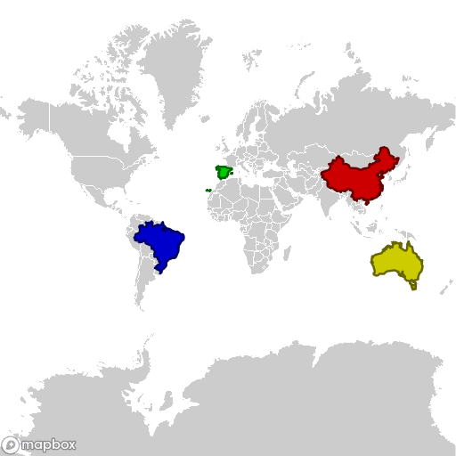
This will show the map of the whole world with the four coloured countries.
Usually only a part of the world needs to be shown. Mapbox uses the Web Mercator projection.
To convert latitude and longitude to Web Mercator coordinates and back the following formulas (coded in Python) can be used:
def latitude_to_webmercator(latitude):
    """Convert a latitude (in degrees) to web mercator."""
    return math.pi - math.log(math.tan((math.pi/2 + math.radians(latitude))/2))

def longitude_to_webmercator(longitude):
    """Convert a longitude (in degrees) to web mercator."""
    return math.radians(longitude) + math.pi

def webmercator_to_latitude(web_mercator):
    """Convert web mercator to latitude (in degrees)."""
    return math.degrees(2 * math.atan(math.exp(math.pi - web_mercator)) - math.pi/2)

def webmercator_to_longitude(web_mercator):
    """Convert web mercator to longitude (in degrees)."""
    return math.degrees(web_mercator - math.pi)
The coordinates in pixels are dependent of the zoom level. The code below calculates the zoom factor and center of the map for the given borders and size.
def get_zoom(web_mercator, pixel):
    """Get the zoom level from size in web mercator and number of pixels."""
    return math.log(pixel * math.pi / web_mercator / 256, 2)

def mapbox_dimensions(south, north, west, east, width, height):
    """
    Get the parameters for a static mapbox image.

    :param south: The southern border (in degrees)
    :param north: The northern border (in degrees)
    :param west: The western border (in degrees)
    :param east: The eastern border (in degrees)
    :param width: The resulting width of the image (in pixels)
    :param height: The resulting width of the image (in pixels)
    :return: a dict with parameters for the mapbox_url function
    """
    # convert to webmercator
    south_wm = latitude_to_webmercator(south)
    north_wm = latitude_to_webmercator(north)
    west_wm = longitude_to_webmercator(west)
    east_wm = longitude_to_webmercator(east)

    # size in web mercator
    width_wm  = east_wm  - west_wm
    height_wm = south_wm - north_wm

    zoom = round(
        max(
            0, # Zoom levels cannot be negative
            min(                             # Calculate zoom levels for
                get_zoom(height_wm, height), # heigth and
                get_zoom(width_wm,  width)   # width
            )                                # and take the lowest value
        )
        , 2 # zoom levels will be rounded to two decimal places
    )
    # Zoom factor to convert web mercator to pixels
    zoom_factor = 256/math.pi * 2**zoom

    return {
        'width':  round(width_wm  * zoom_factor),
        'height': round(height_wm * zoom_factor),
        'latitude':  webmercator_to_latitude( (north_wm + south_wm) / 2),
        'longitude': webmercator_to_longitude((west_wm  + east_wm ) / 2),
        'zoom': zoom,
    }
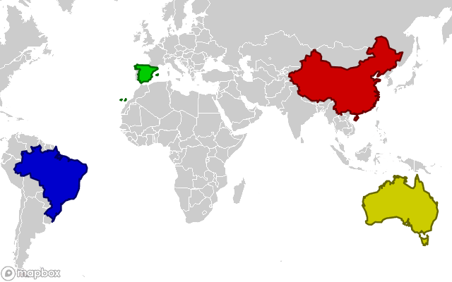
The following borders will be used:
| Direction | Degrees | Name |
|---|---|---|
| North | 53.550000 | Mohe |
| East | 153.638889 | Cape Byron |
| South | -43.643611 | South East Cape |
| West | -73.984444 | Serra do Divisor |
The mapbox_dimensions function converts the borders to
the center latitude and longitude,
the zoom level,
and the width and height of the image.
url = mapbox_url(
    **{
        **mapbox_dimensions(
            south = -43.643611,
            north =  53.550000,
            west  = -73.984444,
            east  = 153.638889,
            width = 640,
            height= 480
        ),
        **{'username': username, 'style': style_id }
    }
)
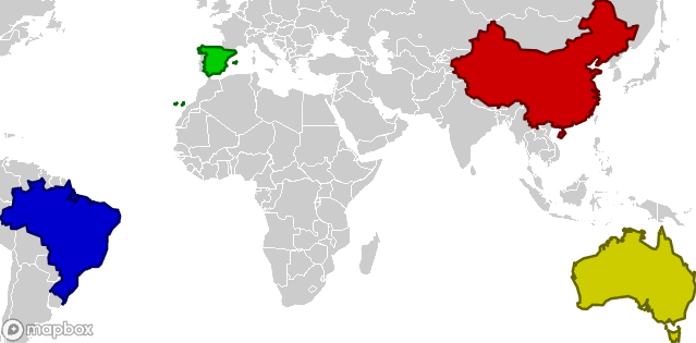
Just as the Google API the size of the image is reduced so the borders in the code are also the borders of the image.
To add a margin to the image, calculate the image with a width and height two times the desired margin smaller.
To get the width and height you desire, add these to the parameters.
url = mapbox_url(
    **{
        **mapbox_dimensions(
            south = -43.643611,
            north =  53.550000,
            west  = -73.984444,
            east  = 153.638889,
            width = 600,
            height= 360
        ),
        **{
            'username': username,
            'style': style_id,
            'width': 640,
            'height': 400,
        }
    }
)
It’s possible to add overlays to the image. The statement to generate a marker can be created with the code below:
def overlay_marker(
    latitude
    , longitude
    , color = ''
    , label = ''
    , size = 's'
):
    """
    Generate the partial url for a marker overlay
    :param latitude:    The latitude of the maker in degrees
    :param longitude:   The longitude of the marker in degrees
    :param color:       The 3- or 6-digit hexadecimal color code
    :param label:       The label, see MapBox documentation for the options.
    :param size:        The size options are 'l' (large) or 's' (small)

    :return: the url part for an marker overlay.
    """
    name = 'pin-s' if 's' == size else 'pin-l'
    if color: color = '+' + color
    if label: label = '-' + label
    return '%(name)s%(label)s%(color)s(%(longitude)s,%(latitude)s)' % locals()
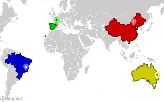
Mark the Olympic cities in the countries:
| Olympic year | City | Latitude | Longitude |
|---|---|---|---|
| 2016 | Rio de Janeiro | -43.205916 | -22.911366 |
| 2008 | Beijing | 116.397500 | 39.906667 |
| 2000 | Sydney | 151.209444 | -33.865000 |
| 1992 | Barcelona | 2.183333 | 41.383333 |
By adding the overlays:
url = mapbox_url(
    **{
        **mapbox_dimensions(
            south = -43.643611,
            north =  53.550000,
            west  = -73.984444,
            east  = 153.638889,
            width = 600,
            height= 360
        ),
        **{
            'username': username,
            'style': style_id,
            'width': 640,
            'height': 400,
            'overlays': [
                overlay_marker(-22.911366, -43.205916, '66F', 'r'), # Rio de Janeiro
                overlay_marker( 39.906667, 116.397500, 'F66', 'p'), # Beijing/Peking
                overlay_marker(-33.865000, 151.209444, 'FF6', 's'), # Sidney
                overlay_marker( 41.383333,   2.183333, '6F6', 'b'), # Barcelona
            ]

        }
    }
)
That gives the final result: